
Tay Heritage Committee

The ‘Hole In The Wall” (or “Mouse Hole”) refers to the remains of a Canadian Pacific Railway (CPR) subway at Hogg Bay, on the former CPR line into Port McNicoll. It recalls the profound impact of the railway era in Tay Township in the century after 1875.
Our Early History
The early history of Tay and North Simcoe stretches back many centuries when First Nation peoples, primarily the Wendat (Hurons), farmed and trapped the area from their villages on local rivers. Their trade with neighbouring villages and tribes followed well-established water routes and overland trails.
Sporadic war with the Iroquois, based in what is now upper New York State. continued until 1649, when a large Iroquois war party attacked and overran several Wendat villages. After the massacre of the Wendat, and the dispersal of the survivors, the Ojibwa and other native peoples, together with European fur traders, moved into the area. In 1798 the Ojibwa sold much of the land in present-day Tay and Tiny Townships to the government of Upper Canada for settlement.
Early Roads in Tay
Tay, Tiny, and several other Townships were first surveyed in 1820.
Road development brought in the earliest settlers to Tay, who took up land near the Penetanguishene Road after the War of 1812. In those days, the Township was largely rural with many farming families.
Many of the first roads in the area followed Indigenous trails. For example, Coldwater Road (later Hwy 12) opened in 1830 and followed the path of the canoe portage from The Narrows at Orillia to the Coldwater River.
After 1832, steamer service on Lake Simcoe and Georgian Bay helped bring in more settlers and freight. In 1844, the Sturgeon Bay Road was opened between Coldwater and Tay Port, at the mouth of the Sturgeon River, which for a time became the embarkation point for passengers travelling to the upper lakes.
The Lumber Era
In the mid-19th century, several forces combined to create a burgeoning lumber industry, based upon the plentiful white pine in the forests along Georgian Bay and the huge demand for sawn lumber in the new towns and cities of the US.
In a few short years, Georgian Bay was lined with sawmills from Collingwood to Britt. Development of the surrounding town sites began as the companies built housing and amenities for the millworkers and managers. As operations expanded, more workers flowed in from Ontario, Quebec, and the US.
By 1879, the extension of the Midland Railway (later the Grand Trunk Railway) west to Midland from Orillia was servicing the local mills and towns, and greatly accelerated development. By 1881, 44% of Township land was occupied with 15% being cleared.
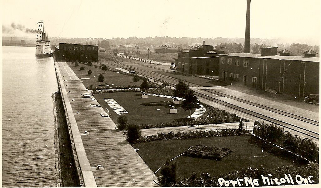
Port McNicoll
After 1905 the Canadian Pacific Railway (CPR) decided to build its own Georgian Bay terminal near Victoria Harbour on the southern shore.
Later named Port McNicoll, the site would provide a fine harbour and a location easily reached by train, resulting in a more direct and shorter route for shipping western wheat to the eastern seaboard.
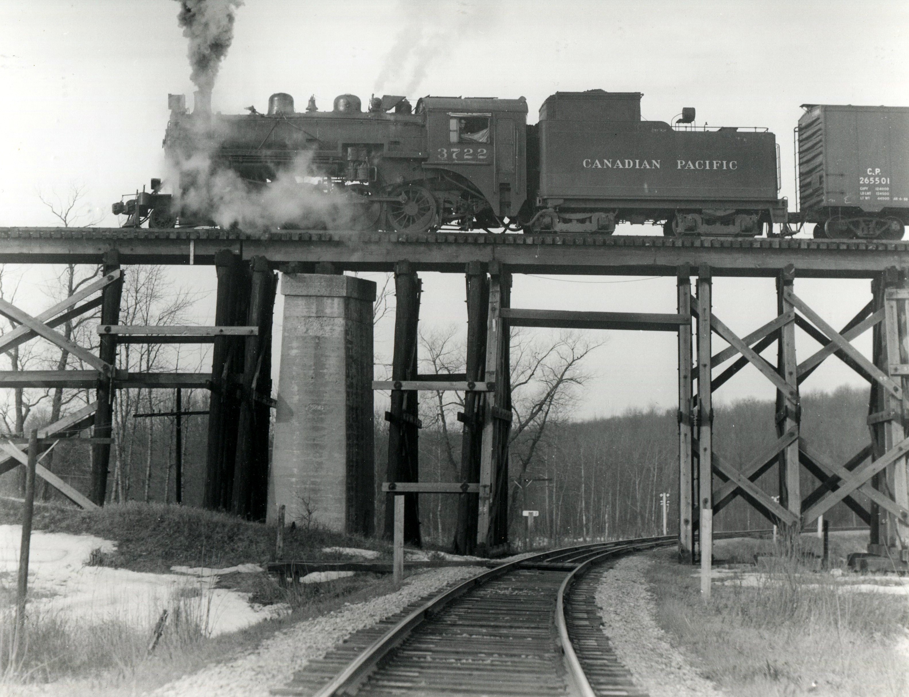
In 1908, construction began on a two-million-bushel grain elevator, a three-thousand-foot wharf, two railway stations, the surrounding town site, and a 2,141-foot-long wooden trestle bridge over Hogg Bay. The CPR completed the rail link from its Coldwater junction in the same year. In 1912, the CPR moved its five-steamship fleet from Owen Sound to Port McNicoll.

CPR ships brought in grain to Port McNicoll and carried passengers on the return trip. CPR freight trains carried grain south and east; CPR passenger trains brought passengers north to the waiting ships. The rail link would extend from Lindsay to Port McNicoll.
The Hole in the Wall

When the CPR decided to build a new Great Lakes port at Port McNicoll, it needed to complete a spur line from its Coldwater junction to the new terminal. However the rival Grand Trunk Railway (GTR) already had a rail line into Midland and would not allow the CPR to cross their line.
Upon reaching the southern shore of Georgian Bay in 1907, the CPR faced the challenge of completing track to Port McNicoll without a level crossing of Hwy 12 or of the rival GTR line, and without skirting Hogg Bay.
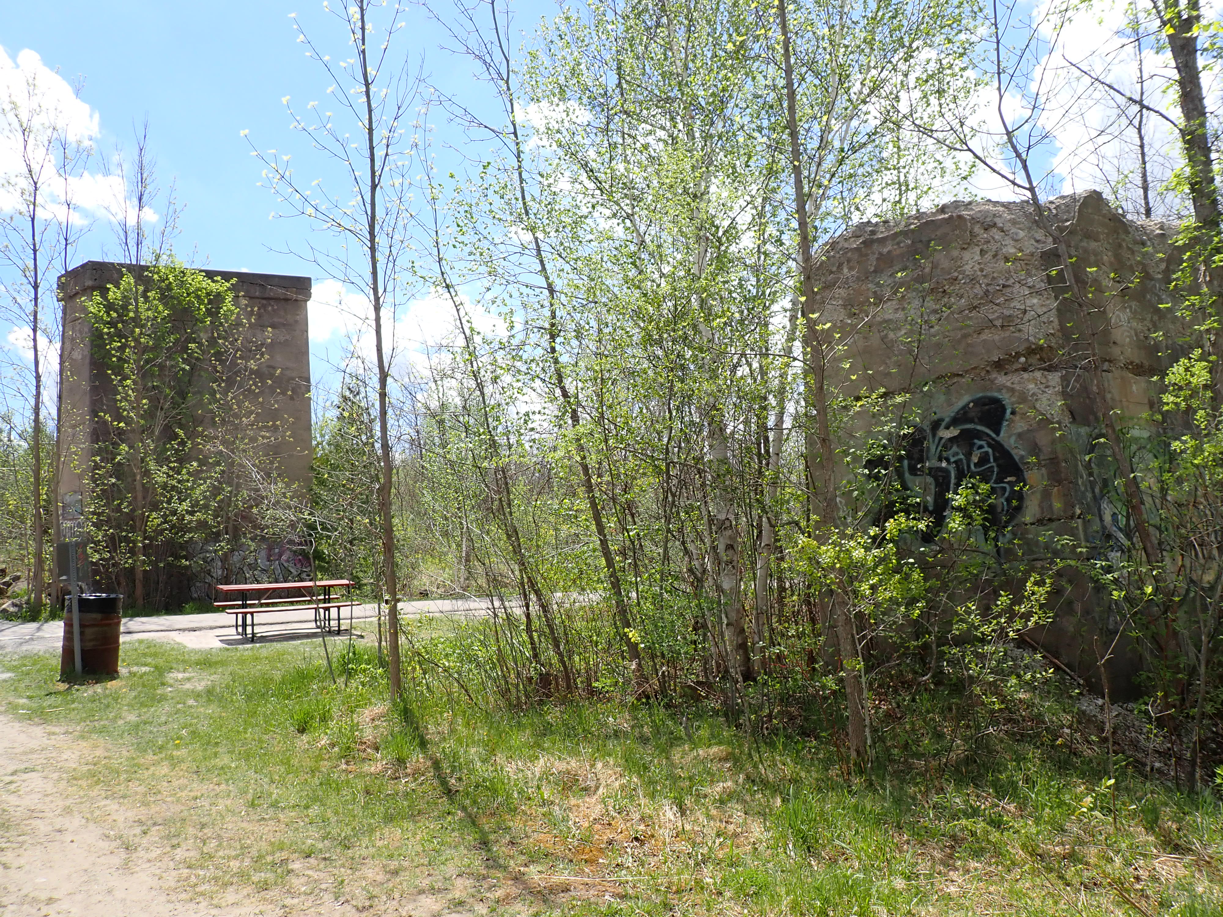
Its solution involved the CPR subway (“the Hole In The Wall”) over Hwy 12, a subsidiary bridge over the GTR line (now the Tay Shore Trail), and the Hogg Bay trestle bridge. (See “The Hog Bay Trestle” at taytownshipheritage@wordpress.com) Construction was complete in 1908.

The subway was designed, c.1907, for horse-drawn carriages and wagons, long before the era of large automobiles and transport trucks. Vehicles on Hwy 12 were to pass (single file?) under freight and passenger trains going to and from Port McNicoll. As commercial vehicles became larger and the movement of goods by transport truck became more prevalent, the Port McNicoll subway became more of a barrier to truck movements on Hwy 12.
The subway had a centreline vertical clearance of only 12 feet (3.65 metres), which forced over-height transport trucks onto lengthy south-bound detours. Trucks occasionally would get stuck, needing to let the air out of their tires so they could be pulled out of the tunnel.
As passenger traffic volume grew on Hwy 12, the subway became a major traffic bottleneck. Consisting of two narrow lanes with low centre clearance, the subway was the site of many mishaps. It was conspicuously marked with large hazard stripes on all sides and had illumination at both portals to aid motorists’ visibility through the subway at night.
While two small oncoming passenger vehicles could pass each other inside the subway (just barely), motorists would usually take turns driving through the subway by yielding the right-of-way to oncoming traffic.
The subway was both feared and loved by local motorists. Feared by cautious drivers who sounded their horn before passing through and avoiding passing others inside the tunnel. Loved by thrill seekers who would dare to pass other vehicles in the tunnel, only to lose a sideview mirror or door handle but sadly, all too often ending with fatalities.
The Hole in the Wall was finally removed from service in 1971, and later bypassed by a much-improved alignment of Hwy 12. The secondary bridge over the Tay Shore Trail has been removed except for the two concrete supports.
The trestle was last used in 1971 and, sadly, was dismantled in 1978 owing to concerns for safety and cost of maintenance


Chronology
1820 Tay Township surveyed
1844 Sturgeon Bay Rd. completed from Coldwater to Sturgeon Bay
1879 The Midland Railway, later The Grand Trunk Railway (GTR), completed from Port Hope to Midland.
1907 The “Hole-in-the Wall” subway completed for the CPR
1908 The Hogg Bay trestle bridge completed
1908 CPR track from Port McNicoll to Coldwater (12 miles) completed
1908 Construction of docks, grain elevator, passenger terminals, etc. in Port McNicoll begun.
1912 CPR track extended from Coldwater to Lindsay (76 miles)
1912 5-ship CPR fleet moved from Owen Sound to Port McNicoll
1965 Train passenger service discontinued
1971 Port McNicoll – Coldwater track, including the Hogg Bay trestle bridge and Hole- in- the -Wall subway, removed from service. The CPR contracted for running rights over CNR track and built new track around Hogg Bay to reach Port McNicoll
c.1975 Realignment of Hwy 12 completed
1978 Trestle bridge demolished
1989 The loss of the federal government grain rate subsidy resulted in the end of grain movements through Port McNicoll
1991 Last freight train from Port McNicoll
Sources
A Brief history of Tay Township at https://taytownshipheritage.wordpress.com/2012/06/12/a-brief-history-of-tay-township/
Cranston, Herbert J. – Huronia, Cradle of Ontario’s History – Historic Huronia Sites Association, 1949.
Haskill, Mary. Nosing into the Past: Life and Times in Huronia. Huronia Museum, 2002
Hunter, F. – A History of Simcoe County – Barrie Ontario, County of Simcoe 1909.
Leitch, Adelaide A.: The Visible Past, the Pictorial History of Simcoe County, The County of Simcoe, 1992
Old Time Trains http://www.trainweb.org/oldtimetrains/CPR_Trenton/Port/History_gbs.htm
Railway Pages, https://railwaypages.com/georgian-bay-seaboard-railway
The King’s Highways, at http://www.thekingshighway.ca/PHOTOS/Hwy12photos.htm
“The Hole In The Wall” at taytownshipheritage.wordpress.com/
Todd, J. Huronia’s Past and Present, Facebook Post 2017
The King’s Highway, http://www.thekingshighway.ca/PHOTOS/Hwy12photos.htm
Tay Heritage at https://taytownshipheritage.wordpress.com/2012/06/12/a-brief-history-of-tay-township/
Todd, J. – Facebook Post 2017
Do you have memories (good or bad) of the Hole In The Wall and/or the Hogg Bay trestle bridge? Please feel free to comment below.

Excellent articles. Thanks
Sent from my iPad
>
Where is this in relation to the current road alignments? I am trying to find it using Google satellite views. It’s not that path passing under Simcoe County Rd. 58, is it?
No sooner did I post my previous comment that I realized that the railroad right of way passed over the ‘subway’, therefore my previous comment regarding County Rd. 58 is incorrect. 🙂
Here’s the location if you’re still looking for it.
https://goo.gl/maps/8zqirvZciv9bdz9w9
Thank you! Your view from the street gave me the exact location. Much appreciated! 😊
Pingback: The Port McNicoll “Mouse Hole” Arch – An odd-looking concrete arch with a railway past – Canadian Military History